

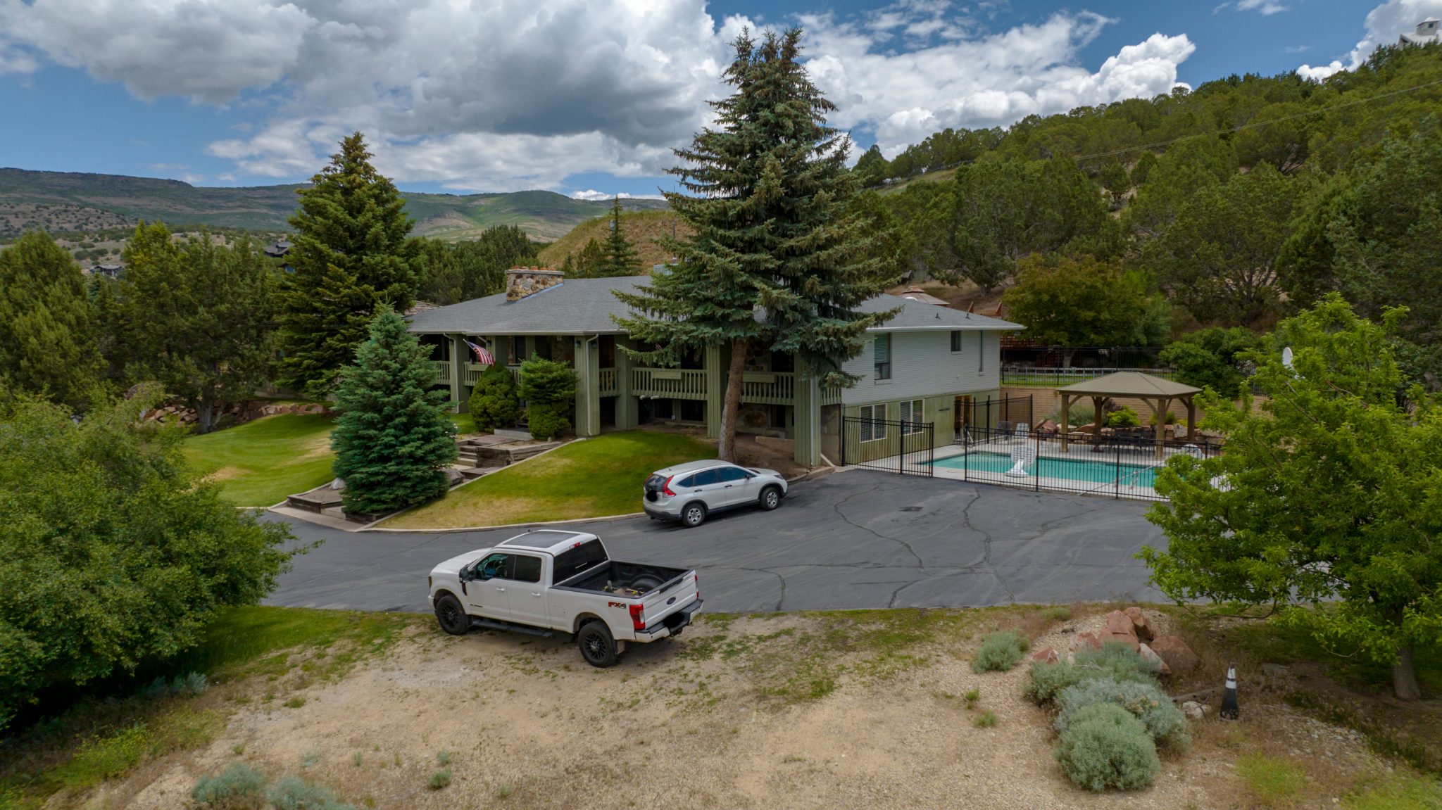
Utah buyers shop for homes on a phone screen long before they drive past a listing. Drone real estate photography gives them the one view a ground camera cannot: the whole property, its lot, and everything around it.
This guide explains when aerial photos and video help a Utah home sell, which shots matter, when to skip the drone, and how to get a listing ready for a flight.
Why drone real estate photography works for Utah listings
Most buyers start online. In the National Association of Realtors 2026 Home Buyers and Sellers Generational Trends report, 52 percent of buyers found the home they purchased on the internet, and 81 percent of buyers who searched online rated photos as very useful, the highest score of any website feature.
That puts pressure on the first few images in a listing. Ground photos show rooms and finishes. Aerial photos show context, and context is what a buyer cannot get from a floor plan.
A single aerial frame can answer questions that would otherwise take a showing:
- Lot size and shape, including the backyard a buyer cannot see from the street
- Property lines, fences, outbuildings and where the neighbors actually sit
- Neighborhood layout, street traffic and how close the home is to parks, trails and schools
- Mountain views and open space that only read from altitude
- Roof condition, solar panels and access for RVs, boats or trailers
For acreage, horse property and view lots, aerial imagery is not a bonus. It is the main event.
The best drone shots and video moves for a listing
More is not better. A listing needs a handful of aerial images that each do a job, plus a short video that keeps a buyer watching.
Five stills every listing should have
- The elevated front: the camera sits just above the rooflines, angled down, showing the home, the lot and the mountains behind it.
- The rear yard from the corner: reveals patios, pools, gardens and the true size of the backyard.
- The neighborhood context shot: high enough to place the home near parks, schools, trails or a golf course.
- The top-down: a straight-down frame that reads like a site plan. Essential for acreage and irregular lots.
- The twilight aerial: taken just after sunset with the interior lights on. It is the image buyers stop scrolling for.
Video moves that hold attention
Aerial video works best when each move has a purpose and the clip stays short.
- Orbit: a slow circle around the home that shows every elevation and the surrounding lot in one shot.
- Reveal: the drone rises over a tree line, a ridge or the roof to unveil the home or the view behind it.
- Push-in: a straight approach from the street to the front door, useful as the opening shot.
- Top-down pull-back: starts directly above the home and climbs to show the full parcel. The best move for acreage.
- Twilight orbit: the orbit repeated at dusk with the lights on, for the closing shot.
Keep the MLS and social cut under two minutes. Longer edits, like the 3 to 6 minute tours in our Silver and Gold packages, belong on a dedicated property website or YouTube, where a buyer has already chosen to watch.
When drone real estate photography does not add value
Honest advice earns more trust than a flight that produces nothing useful. Skip the drone, or scale it back, in these situations.
Small lots and tight neighbors
A townhome on a small lot with neighbors a few feet away gains little from altitude. The aerial frame mostly shows other rooftops. One elevated front photo may still help, but a full aerial package will not.
Homes with nothing to show from above
If the roof is tired, the yard is unfinished, or the view is a freeway, an aerial photo puts the weakness on the cover. Fix it first, or lead with interior images instead.
Restricted airspace
Drones flying under 400 feet in controlled airspace around airports need an FAA authorization before takeoff, usually through the LAANC system.
Much of the Salt Lake Valley sits under Salt Lake City International’s controlled airspace, and the area nearest the runways is off limits to drones entirely. Hill Air Force Base and regional airports such as Provo and Ogden add their own controlled airspace.
A certified pilot can often get an authorization in near real time, but some addresses come with a lower altitude ceiling or a manual request that takes longer. Ask before you promise a client aerial photos.
Weather and season
Wind, fresh snow on the roof, and inversion haze all degrade aerial images. A good pilot will reschedule rather than deliver flat, gray frames.
How to prepare a listing for a drone shoot
Aerial photos show everything, including the things a ground photographer can crop out. A short checklist before the flight makes a visible difference.
- Clear the driveway and street frontage. Cars, trailers and trash cans dominate a top-down frame.
- Mow, edge and water the lawn a few days ahead so the grass reads green from above.
- Put away pool covers, hoses, toys and yard equipment. Open patio umbrellas and stage outdoor furniture.
- Check the roof for debris, tarps or broken shingles. Aerial images make roof condition obvious.
- For twilight shots, turn on every interior and exterior light, including landscape lighting.
- Tell the neighbors. A quick heads-up avoids complaints and keeps the shoot calm.
- Share the parcel boundaries or a plat map with the pilot so property lines can be shown accurately.
Under Utah Code 76-12-302, a drone flown for legitimate commercial purposes in a manner consistent with FAA rules is not a privacy violation, as long as any recording of a neighbor’s private space is solely incidental to that commercial use. Professional pilots keep the camera on the listing and do not linger over adjacent yards.
The Utah angle: mountains, big lots and seasonal light
Utah gives drone real estate photography advantages that most markets do not have.
Mountain backdrops
Along the Wasatch Front, a short climb above the rooflines puts Timpanogos, Lone Peak or Ben Lomond behind the home. That single frame communicates Utah faster than any caption.
Large lots in Utah County and Washington County
Large lots are common in places like Eagle Mountain, Saratoga Springs, Alpine, American Fork and the benches above Provo and Orem. In Washington County, view lots around St. George sit against red rock and open desert, and Cedar City to the north pairs high-desert lots with mountain views. In both areas, buyers need to see the full parcel and its surroundings, and only an aerial can do that.
Seasonal light
Utah’s dry air produces clean, high-contrast light most of the year. The trade-offs: winter inversions flatten the valley floor, summer wildfire smoke can wash out distant peaks, and snow hides landscaping. Spring and fall deliver the most reliable color, and twilight works in every season.
How Utah Drone delivers real estate photography
Our FAA Part 107 certified pilots shoot listings across the state, from Logan to St. George. Every flight includes an airspace check, LAANC authorization where needed, and edited photos and video delivered through a secure online gallery, sized for the MLS, websites and social media. See the full scope on our real estate drone services page.
Current options are listed on our real estate drone packages and pricing page. At the time of writing:
| Package | Price | Aerial photos | Edited video |
|---|---|---|---|
| Bronze | $299 | 15 | 1 to 2 minutes |
| Silver | $499 | 25 | 3 to 4 minutes, plus a 15 to 30 second highlight reel |
| Gold | $899 | 40 | 5 to 6 minute cinematic tour with voice-over |
We aim for a one to three business day turnaround on every package.
Travel is included within 30 miles for Bronze, 50 miles for Silver and 75 miles for Gold. Listings farther out add a travel fee, which we quote before booking.
Need ground photography, an indoor drone flythrough or a custom edit? Those options are listed on our real estate drone services page, and our aerial photography and videography team can build a package around the listing.
Frequently asked questions
How much does drone real estate photography cost in Utah?
Our packages start at $299 for 15 aerial photos and a short edited video. Larger properties and cinematic tours cost more. Current pricing is on the packages page linked above.
Do I need permission to fly a drone over a home for sale?
The pilot needs an FAA remote pilot certificate for commercial work, plus an airspace authorization if the property sits near an airport. The seller’s permission covers the listing itself. Neighboring yards should be avoided.
How long does a drone shoot take?
Our Bronze package includes up to 30 minutes of flight time, Silver up to 60 minutes and Gold up to 90 minutes, which covers most residential listings. Twilight shoots add a short wait for the right light.
Can drones fly in winter in Utah?
Yes, with limits. Cold shortens battery time, and snow on the roof hides detail. Clear days after a storm can produce striking mountain images, but inversion days are worth skipping.
Should I order aerial video or just photos?
Photos carry the MLS listing. Video drives social media and property websites. For most homes, a small set of stills plus a 60 to 90 second clip is the best return.
Book drone real estate photography for your Utah listing
Ready to put the whole property in front of buyers? Call us at (385) 417-4017, email contact@utahdronevideo.com, or send the address through our contact page. We will check the airspace, confirm the best time of day, and get your listing in the air.