

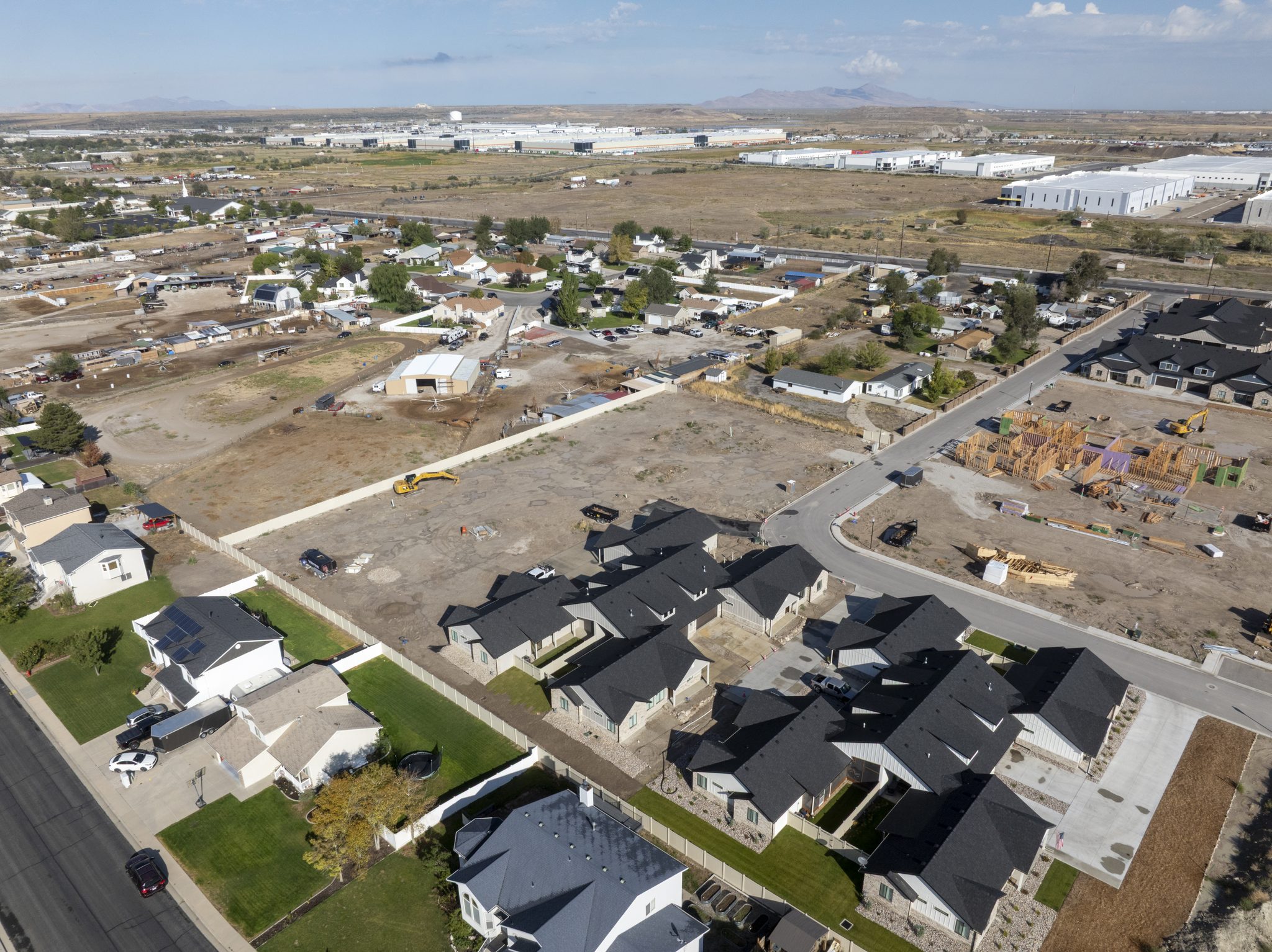
Construction drone photography gives Utah builders a dated, complete record of a job site from the first cut of dirt to the final walk-through. A licensed pilot flies the same route on a set schedule, and you get consistent aerial photos, video and site maps that show exactly what was built and when.
This guide explains what construction drone photography includes, how a progress program is set up, the FAA rules that apply on a Utah job site, and what to ask before you hire a pilot. It is written for general contractors, developers, superintendents and home builders working anywhere in the state.
What construction drone photography includes
The term covers more than a pretty flyover. A good construction drone program usually delivers several products from each visit:
- Progress photos from fixed positions and heights, repeated on every flight so each set lines up with the last
- Top-down site overviews that show lot lines, staging areas, roads, utilities and material laydown in one frame
- Short video flyovers for owner updates, lender draws and project meetings
- Orthomosaic maps stitched from hundreds of overlapping photos for measuring and planning
- Inspection close-ups of roofs, facades, cranes, scaffolding and other hard-to-reach work
- Marketing imagery of finished phases for sales offices, websites and investor decks
Most builders start with monthly progress photos and add mapping or inspection flights when a project needs them. Our construction and inspection drone services page describes the options in more detail.
Why Utah builders are putting drones on the job site
Drone use in construction is now mainstream. In a May 2026 survey by Associated Builders and Contractors, 36.1% of responding contractor members said they fly drones, and the most common use was site progress monitoring at 80.8%, followed by marketing and media at 77.5% and inspections at 50% (ABC Drone Usage report).
The same report found that regulatory and compliance issues were the biggest hurdle to adoption, cited by 53.5% of respondents. That is one reason many Utah builders hire a Part 107 operator instead of training in-house crews.
The demand is here. Construction added 4,300 jobs in Utah over the twelve months ending July 2026, the third largest gain of any industry in the state (Utah Department of Workforce Services employment summary). More active projects mean more owners, lenders and inspectors who want to see progress without driving to the site.
Progress documentation that holds up
A photo taken from the same spot every month is hard to argue with. When a question comes up about when a slab was poured, when framing finished or where a subcontractor staged material, a dated aerial set answers it in seconds.
That record is useful for pay applications, change orders, schedule reviews and, if it ever comes to that, disputes and claims. It is also a simple way to show a client in another state that their project is on track.
Fewer site walks and safer looks at height
Drones let a superintendent see the roof deck, the top of a crane or the far corner of a 40-acre site without climbing or walking it. The pilot stays on the ground the whole time, and nobody has to go up a ladder for a photo.
How a construction drone photography program works
The value comes from consistency. Here is the process our pilots follow on a typical Utah project:
- Baseline flight. Before or just after mobilization, the pilot captures the site as it exists. This becomes the reference for every later set.
- Fixed shot list. Together we set the camera positions, headings, altitudes and the top-down grid. These are saved so each flight repeats them.
- Set cadence. Most projects fly every two to four weeks, with extra flights at milestones such as foundation, topping out and dry-in.
- Same conditions. Flights are scheduled for similar times of day so shadows and light match from month to month.
- Delivery. Organized photos, video and any maps are delivered in a shared folder, labeled by date and position, usually within 1 to 3 business days.

A straight-down overview like the one above shows the whole site at once: finished units, the street, lumber and trusses staged on open lots, and equipment parked for the day. Repeating that frame every month turns into a clear timeline.
Choosing a flight cadence
The right schedule depends on how fast the site changes and who needs the updates. The table below compares the three most common options.
| Cadence | Best for | What you get |
|---|---|---|
| Milestone only | Small projects and single homes | Four to six flights at key stages |
| Monthly | Most commercial and multifamily jobs | A matching set every month plus a video update |
| Every two weeks | Fast-moving sites and lender reporting | Tight timeline with fewer gaps between sets |
- Add a mapping flight at grading and again at final grade if you need volumes or as-built checks
- Add a marketing flight when the exterior is finished and the site is clean
- Add an inspection flight for roofs, facades or any work that is hard to reach safely
What to capture on every flight
A repeatable shot list keeps the record complete. On most projects it includes:
- Four oblique overviews, one from each corner of the site
- One straight-down frame of the full site at a fixed altitude
- Close views of the current work: footings, framing, roofing, exterior finishes
- Laydown yards, access roads, erosion controls and fencing
- A short orbit video of the main structure

Low, detailed frames like this one record material staging, equipment and site conditions that a high overview misses. Together they give a complete picture of the work that month.
Drone mapping for grading, volumes and as-builts
When a project needs measurements rather than pictures, the pilot flies a mapping grid with high overlap. Software stitches the images into an orthomosaic, a scaled top-down map, and a 3D surface model.
Builders use these maps to check cut and fill, measure stockpiles, compare the site to the civil plans and share a current base map with subs. Learn more on our surveying and mapping drone services page.
A drone map supports planning and progress tracking. It does not replace a licensed surveyor for boundary work, legal descriptions or stamped survey products.
FAA rules for construction drone photography in Utah
Any flight for a builder is a commercial operation, so it falls under FAA Part 107. The pilot must hold a remote pilot certificate and follow the operating limits in the rule.
Part 107 caps altitude at 400 feet above the ground, with an exception that lets the drone fly higher within a 400-foot radius of a structure as long as it stays within 400 feet of the structure’s top. It also limits groundspeed to 87 knots and requires at least 3 statute miles of visibility from the control station (14 CFR 107.51 operating limitations). The structure exception matters for tall buildings and tower cranes.
Airspace is the other big factor. No one may fly a small drone in Class B, C or D airspace, or in the surface area of Class E airspace designated for an airport, without prior authorization from air traffic control (14 CFR 107.41). Many job sites along the Wasatch Front and near regional airports sit inside that controlled airspace, so the pilot checks the map and secures authorization before every flight.
Other rules the pilot manages for you:
- The drone stays within the pilot’s visual line of sight for the entire flight
- Flights over people are restricted unless they are part of the operation, under cover or the drone meets a category for over-people flight, so crews may be asked to move during a pass
- Night flights need anti-collision lighting visible for at least 3 statute miles
- The aircraft must be registered and broadcast Remote ID
Who uses construction drone photography
One flight serves several people on the same project:
- General contractors verify subcontractor progress, sequence and site logistics
- Owners and developers get board-ready updates without a site visit
- Lenders confirm work in place before releasing a draw
- Architects and engineers compare built conditions to the drawings
- Marketing teams turn finished phases into listing and leasing content with our marketing and advertising drone services
Our pilots fly projects statewide. See our Utah service areas for coverage near your site.
How to choose a construction drone photography provider
Ask these questions before you sign a progress contract:
- Do you hold a current FAA Part 107 remote pilot certificate, and can you show it?
- Do you carry liability insurance for drone operations, and can you add our company as additional insured?
- How do you repeat the same shots from flight to flight?
- How do you handle controlled airspace and authorizations near airports?
- What is your turnaround, and how are files organized and delivered?
- Can you add mapping, inspection or marketing flights to the same visit?
- Who owns the images, and can we use them in reports, marketing and legal matters?
Price depends on site size, cadence, deliverables and travel. A single-home milestone package costs far less than a biweekly program on a 30-acre commercial site, so ask for a quote tied to your actual schedule.
Frequently asked questions
How often should a construction site be photographed by drone?
Monthly is the most common cadence for commercial and multifamily work. Fast-moving or lender-reported projects often go to every two weeks, and single homes usually do well with milestone flights.
Can a drone fly over an active job site with workers?
Yes, with planning. The pilot avoids flying directly over people unless the rules allow it, coordinates with the superintendent and times passes so crews are clear. The flight itself usually takes less than an hour.
Do I need to stop work during a drone flight?
Usually not. Most progress flights happen around the active work with no stoppage. Crane lifts and concrete pours are coordinated in advance so the drone stays clear.
Can drone photos be used in a construction dispute?
Dated, consistent aerial photos are strong documentation of site conditions on a given day. How they are used in a claim is a question for your attorney, but having the record is far better than not having it.
Is a drone map accurate enough for a survey?
A drone map is excellent for planning, progress tracking and volume estimates. Boundary and legal survey work still requires a licensed land surveyor.
Start a construction drone photography program in Utah
Whether you need one milestone flight or a monthly program across several sites, Utah Drone can set it up. Our FAA Part 107 certified pilots fly statewide and aim to deliver within 1 to 3 business days.
Call (385) 417-4017, email contact@utahdronevideo.com or request a quote on our contact page.